
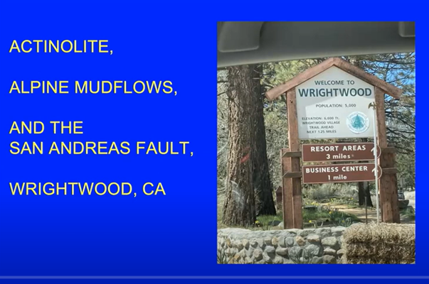
Actinolite, Alpine Mudflows, and the San Andreas Fault, presented by Debra Brooks
by Andy Thompson, MSDC Secretary
This report is provided to encourage readers to visit MSDC’s YouTube channel to view the video of Debra’s presentation in its entirety including the follow-up question and answer session. It runs for about 68 minutes.
Geology Professor Emerita Debra Brooks began her presentation by saying that she would explain the interesting interplay between three realities: actinolite, Alpine mud flows and the San Andreas Fault:
“This is a talk about actinolite, a mineral that is easy to collect in my part of the world . . . because of what they colloquially call ‘alpine mud flows,’ a type of landslide, and because (the flows) take place near the town of Wrightwood, CA which sits atop the San Andreas Fault.”
That description set the stage for Debra leading her audience on a well-documented field trip which explained the mineral actinolite and its availability due to mud flows associated with local terrain and the San Andreas fault.
The Mineral Actinolite
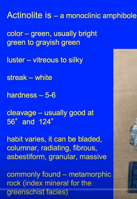
Debra’s slide below provided a physical description of actinolite as follows.
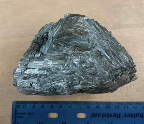
One of its characteristics that makes this mineral so interesting for Debra is its long fibers which are typical of the specimens you find at 6,000 feet, on the mud flats, and the Pelona Schist which underlies the town of Wrightwood.
Debra said that most of the time “people collect it (actinolite) because it is pretty.” But for more serious mineral collectors, she advised they would want to be able to identify the tell-tale differences between actinolite and its mineralogical cousins, other minerals which make up the solid solution series of which actinolite is a part.
She provided very helpful clues to properly identify actinolite and distinguish it from its three sister minerals. As noted below, for example, the chemical formula for actinolite can include varying amounts of magnesium and iron. When the specimen has magnesium but lacks iron, the collector is holding tremolite. When it has iron but no magnesium, the specimen is ferro-actinolite. And, what happens if it holds magnesium and iron but also chromium? Then it is the mineral smaragdite.
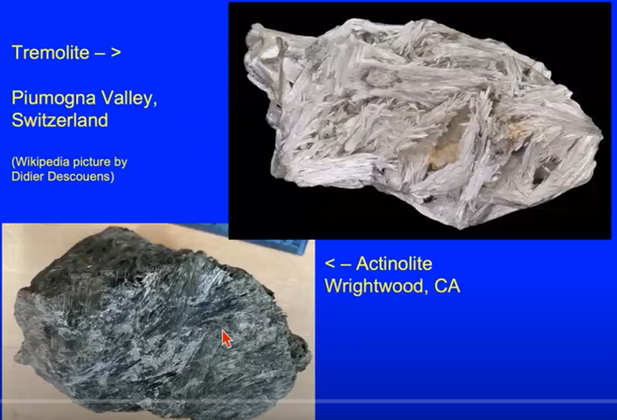
But how is a collector able to identify these sister minerals of actinolite? Hint: pay attention to the shade of the green color (details in the video of Debra’s talk). Debra listed the needed distinguishing information on colors.

She noted that sometimes it's possible to identify the mineral based on the color of the specimens. For example, tremolite and actinolite, shown below, have much the same fibrous appearance, with tremolite being more fibrous. The colors, however, are distinctive. Nonetheless, Debra noted that "sometimes a chem lab is needed to be sure of the mineral’s identity.”
Debra helped her audience dig into the process by which actinolite, a metamorphic rock, forms from its source rock, Pelona Schist, specifically from the greenschist. For a full explanation, watch the video of her talk.
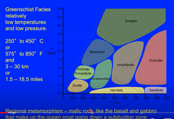
In the chart above, we can see that greenschist, which is mafic in nature (i.e., high in magnesium and ferric oxides), formed when the pressure (vertical axis) was relatively low to medium and the temperature (horizontal axis) was relatively low. The low to medium pressure, Debra noted, is consistent with why the actinolite is found relatively close to the surface, making it available for collectors on the mudflats which is the second theme of her presentation.
Alpine Mudflows
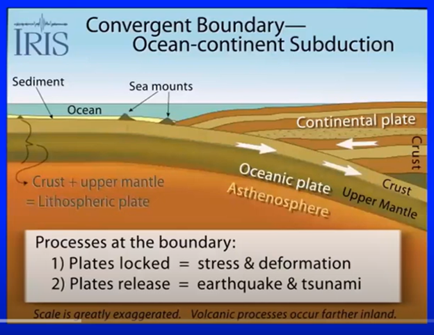
Debra explained the origin of this region and eventually of the mudflats starting with tectonic activity 100 million years ago. It began with the subduction of the Farallon oceanic plate plunging below the continental plate, as illustrated below. Just to the right of the “sea mounts” is where the relevant action occurred and Debra provided a short video to help explain the complexities of the processes which changed over time.
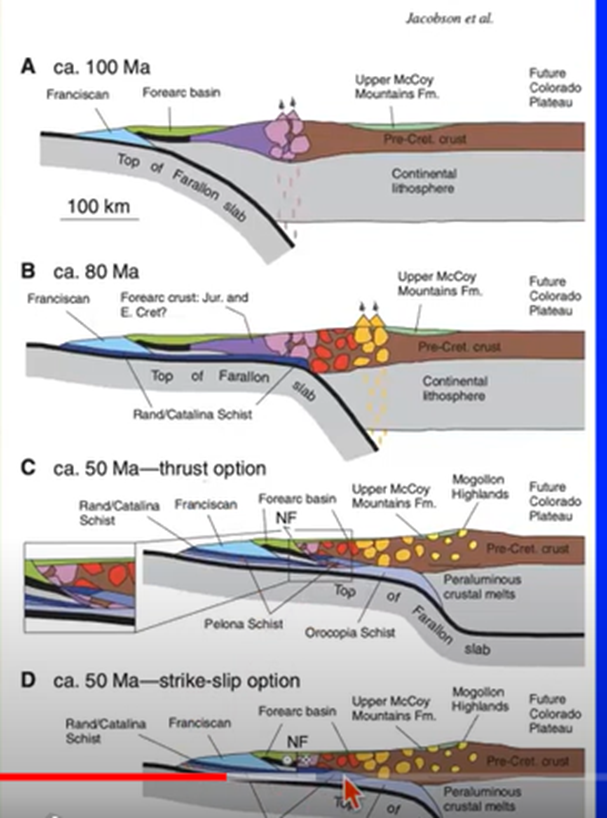
Fast forward from 100 million years ago, Figure A below, to about 50 million years ago, Figure D, through the description of possible plate subduction phases. Notice the tiny red arrow at the very bottom of Figure D. That, Debra said, is where the overburden has eroded, exposing the layer of rock which contains the actinolite that is found today.
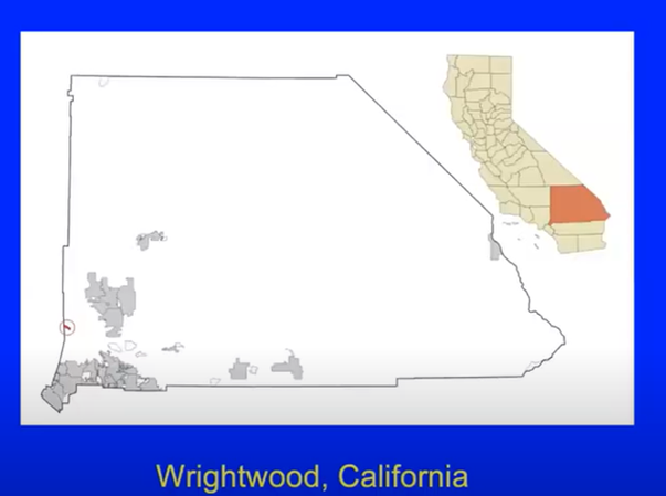
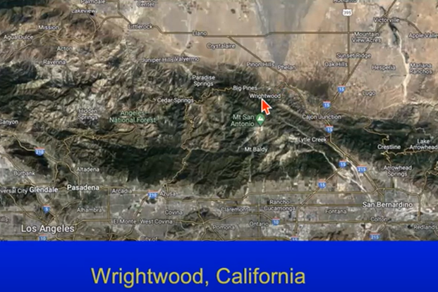
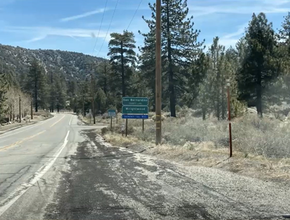
The small town of Wrightwood, California is in San Bernardino County and is bordered by Route 2 on the east, the Mountain High East Yetis Snow Park on the north, and Blue Ridge Mount on the south. The town site is designated below by the tiny red line and circle on the far left of the map below. The grey areas are the populated regions of the County. The white areas in between the grey is the geographic area where the crustal accumulation of broken rock and actinolite are found today.
It is from Wright Mountain in the Blue Ridge that the erosion and annual Alpine mudflows have traveled and been deposited. The 1941 flow all but totally destroyed the town.
Watch the video and you will learn about the interesting clash between the scientific and government agencies which together were opposing the local political and financial interests with regard to the question of rebuilding Wrightwood after the 1941 destruction. Readers of this report will be rewarded by going to the YouTube video of Debra’s entire presentation and listening to her sharing aspects of her students’ intriguing field trip
The San Andreas Fault
We come now to the third theme of Debra’s presentation, the San Andreas Fault. Over the centuries and even in recent decades, Debra noted the area around Wrightwood has suffered greatly from its geologic heritage thanks to is location directly atop the San Andreas Fault and the dynamics of the plate tectonic activity described earlier.
Below is a satellite view which Debra used to show how field collectors can travel from Los Angeles (bottom left), driving east and then north to Wrightwood, designated by the red arrow.
Debra suggested that the terminology to describe the area as having an “Alpine” mudflow, which is not a geological term, was used by civic and business leaders to attract more tourists and skiers to the area.
As a native of San Bernardino County and a geology professor who over decades has led a large number of field trips to the area to collect actinolite, Debra’s presentation is a treasure trove of information about the history of the area, what you will discover as you travel to get there, and practical details about how to have a successful visit.
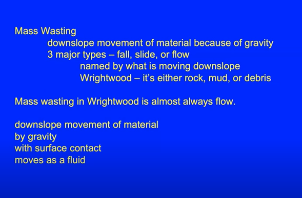
She noted that an important part of this field trip is understanding what you are seeing when you arrive. This preparation includes knowing the nature of the annual mudslides which, in the Wrightwood area, is the “flow” type of mass wasting, the downslope movement of debris, rock and mud, as noted below.
The factors which influence the extent of the landslides and mudflows depends not only on environmental factors, but also on the geological factors. The younger the rock, she said, the greater the instability of the rock formation. Palona Schist, being generally less than 50 million years old, is considered “young.” That, along with the amount of rainfall, temperature, frequency and severity of the earthquakes, all contribute to the abundance of mass wasting flows.
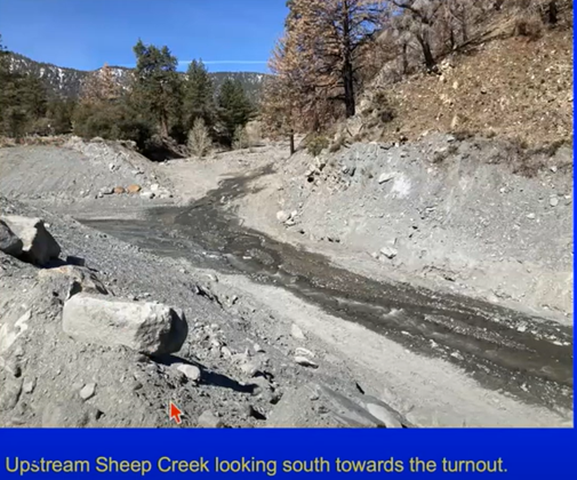
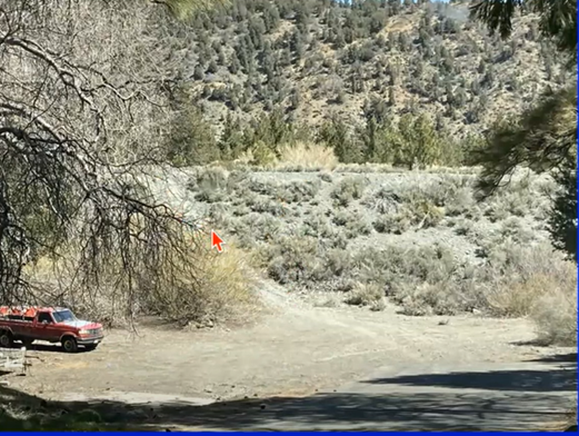
In order to learn the significance of the following photos and additional sites, we encourage readers to view the tape of Debra’s information-packed, comprehensive and enjoyable presentation.
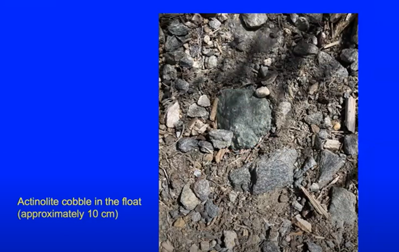
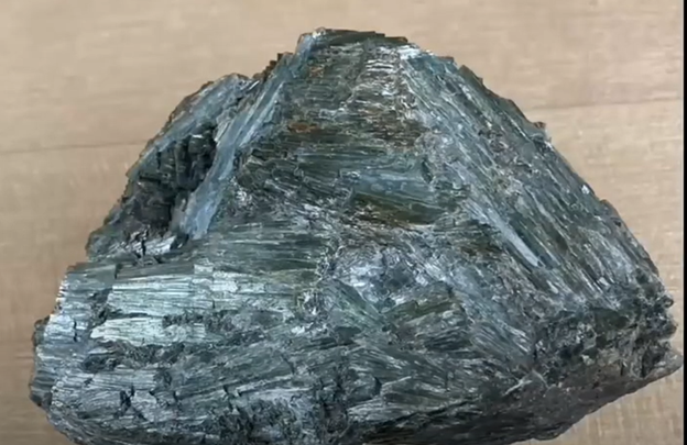
Near the above Court, Debra discovered the beautiful green 4” by 4” square-looking actinolite specimen shown above along with many more examples found in the immediate area. Her numerous field trips helped students understand the dynamics of the Alpine mudflows and the challenges of Wrightwood’s tenuous location along the San Andreas fault. Additionally, occasional trips for collecting large amounts of actinolite helped fund the Santiago Canyon College’s geology department’s purchases of its mineral collection.
Closing Comments
MSDC President Ken and VP Cindy thanked Debra for her extraordinary presentation and the attendees expressed their appreciation with applause. The floor then was opened for questions which ranged from “geodynamics” to the effectiveness of the Corps of Engineers’ interventions, and fiscal benefits of the students and friends’ field collections and sales.
To view the video of Debra’s presentation in its entirety, click HERE or on the following link: https://www.youtube.com/watch?v=43wJoV0fAr0.