
From the Archives from September 2020:
Blast From the Past – December 2010: Geology of the Great Falls of the Potomac and Mather Gorge with a comment about Sugarloaf Mountain
by Scott Southworth as reported by Betty Thompson
Scott Southworth has been a geologist with the U.S. Geological Survey (USGS) for 30 years. His interest in rocks began when he was a youngster finding sharks’ teeth east of Fredericksburg, VA, along the Potomac River. That curiosity continues to yield extensive research about the Piedmont and a tall pile of publications, many available online through USGS. They include 34 USGS catalog items, like Geology of Loudon County and Geology of the National Capital Region (2004), which won the Geoscience Information Society’s Best Guidebook award and was produced in association with the Geological Society of America regional meeting. His Geology of the C&O Canal (USGS Professional Paper 1691) also won the Geoscience Information Society’s Best Guidebook award.
Scott had prepared a presentation that focuses on the Piedmont. However, at the absolute last moment, it became clear that the MSDC-supplied computer could not support the later software version of his presentation. Drawing on his immense expertise and equally impressive flexibility and with zero prep time, he gave an impromptu geological tour of the Great Falls of the Potomac and Mather Gorge, just below the Falls. He used beautiful slides that David and Leslie Nanney had taken there the prior weekend, which they had shown briefly as a prequel to his planned presentation. So this talk became a prequel to the Piedmont presentation, which he will most graciously give at a future meeting.
A number of years after Avery Drake at the USGS asked Scott to work with him on the western Piedmont, Scott decided also to explore the “backyard” of his Virginia home: the C&O Canal and great Falls. He noted that National Park Service staff often must focus on managing their parks, with little time to explore the land itself. So, as part of their sister agency in the Department of the Interior, the USGS, Scott began to tell them much more about the land they manage at Great Falls National Park.
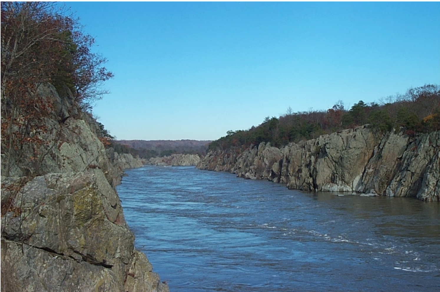
The Potomac’s fall line is where the upland bedrock becomes alluvial or marine coastal plain. The upland bedrock dates to before and during the Taconic orogeny, about 600-440 million years ago. Below the Falls, Theodore Roosevelt Island is an eroded bedrock island. If you cross the Roosevelt Bridge, the outcrop on the north side of the bridge is the last outcrop of the Piedmont. After that, it’s alluvial sediment deposited on bedrock. The major cities of New York, Philadelphia, Washington, DC, and Richmond lie on this line where sediment overlaps bedrock, because ships could reach these locations below the falls of various rivers while the falls themselves provided energy for commerce.
Nowhere are the rocks of this geological structure clearer than at Great Falls. Our entire area sits on the same rock formation, but the waters of the Potomac have exposed them at Great Falls. Geologists name rock formations based on the locality where they are best observed. Originally the rock formation that includes our area was named the Wissahickon after the creek near Philadelphia where the formation was first identified. In the 1950s, geologists documented similar rocks in our area. (Remember that this was before the recognition of continental drift or plate tectonics.) In the 1980s, Avery Drake of the USGS pointed out that Mather Gorge is the best place to see these rocks and therefore the formation is now called Mather Gorge.
The formation is composed of metagraywacke and schist. Graywacke (a hard, dark sandstone with quartz and feldspar in a compact clay matrix) is thicker and very resistant, which explains why Great Falls is where it is. Greywacke and schist are integrated and interrelated at all scales; you can’t really map the separation unless you choose to simply show the dominant material at a particular point. Rocks like these are very difficult to work with because the metamorphic material got so hot and was buried so deeply. Scott used the Nanneys’ slides to illustrate this formation.
In other slides, he focused on Bear Island. Bear Island is mostly bedrock, maybe with some sediment-filled potholes. There is a migmatite zone on the southern end of Bear Island, with gorgeous wavy marbleized forms, crystallized and partially reconstituted. There are no fossils here because these formations likely predate fossils!
Igneous rocks are dated through their zircon crystals. The rock shows lots of erosional features like channels and potholes; if you remove quartz grains from them, analysis can tell you when it was exposed to the sea. Studies show that the dominant erosion event in the Mather Gorge was about 35,000 years ago. The Gorge was not cut out by glaciation. Although the Laurentide ice sheet was huge, from the Arctic to central Pennsylvania and a full mile thick, it didn’t come this far south. It caused the climate here to be very cool, with howling winds. But the Mather Gorge erosion came from the later glacial outwash and rains, not from the glacier itself.
Along Great Falls, some of the erosional channels have a very unusual step-like appearance. Don’t be fooled: these steps were carved in recent years as fish ladders to help the shad, herring and other fish to get upstream, past the falls! At the top of the cliffs that line the gorge, one area is labeled “bedrock terrace forest” but the forest itself is only about 70 years old. The area was clear-cut more than once.
It’s hard for a forest to grow on bedrock, but there are many plants that have made homes here; some may be rare. Scott noted that the Potomac River “bulldozed” the parking lots on the Virginia side of Great Falls Park, exposing the bedrock and then, about 35,000 years ago, cutting down to the level of Bear Island’s bedrock. Those who’ve studied this think it was probably a very rapid process. Bear Island is the only place in the gorge where you can take a mineral sample and get true lab results. Other rocks in the gorge have been so affected by what has happened since their formation that they are almost impossible to date.
In another slide, he pointed out that the gorge holds a lot of exotic rock materials. There are 3-foot-diameter boulders as well as many other rounded alluvial rocks that have rolled here via the Potomac headwaters from Seneca and Harpers Ferry.
Several slides gave lovely views of vein quartz, often with folds. The quartz was introduced as fluid during deformation, which results in transposition. Others showed a fairly rare formation of fine parallel lines or ripples: mesoscopic vein quartz and pin-striped gneiss. This occurred because individual seams of quartz were rejected during deformation and cut by vein quartz. The cracks opened due to Mesozoic expansion as the Atlantic was opening up. The quartz carried the gold that has been mined in many Maryland creeks.
The photos included beautiful views of the rock face. The obvious upright strips and lines are the original layers of sediment, now rock and now upended in a dramatic illustration of geological change. Potassium and feldspar crystals have been found, as well as turbidites, which are formed during sudden deep drops of sediment into an oceanic trench (as in Monterey Canyon in California; see USGS website). The rocks show soft features that are sediment deformations which occurred deep underwater and due to gravity. In some areas of the gorge there has been too much geological action to get an accurate orientation of the rock.
The obvious upright fractures in the rock face give wonderful evidence of the Taconic orogeny. On the tops of the rock face are lamprophyre dikes of Devonian age, 360 million years old. But if you put your arm down into a fracture, you can literally reach back into time. The fractures cut through, straight as an arrow, with no folds, into rock that was deformed about 475 million years old; dikes intruded and created the fractures 360 million years ago. The wondrous part: these long fissures have not changed since then; the fractures remain as straight as when they formed so many ages ago. And here at Great Falls, they are visible from far distances.
Another marvel: Mather Gorge is so straight that it could look man-made. Scott commented that you could lay a 5-kilometer ruler along the gorge. But there are no cross-fractures in the rocks along its parallel sides. Given that regularity, Scott noted that geologists draw a fault line along the gorge with very little evidence; the only way to prove the existence of a fault would be to drain the river.
In response to a question, Scott also shed light on Sugarloaf Mountain in Maryland. As a monadnock (an isolated small mountain), Sugarloaf has always been an attraction for people. It’s very complicated rock – a very resistant quartzite surrounded by softer rock in the Urbana formation, together with very deformed slates.
In the 1950’s, John Hopkins University students under David Scotford and Dick Nickelsen devised a method of outcrop mapping. Most people think that geologists map by doing transects, that is, by walking across rock in several places and “connecting the dots.” Instead, this team pioneered a really wise method: they walked a rock bed and mapped it as it lay. When Scott did the same at Sugarloaf, it was clear that Sugarloaf is part of the Weverton Formation of the Chilhowee Group, the same as in the Catoctin Mountains. This is Blue Ridge stratigraphy popping up through the Piedmont, which sounds complicated but became really simple in Scott’s quick free-hand drawing.
The Frederick Valley is Cambro-Ordovician limestone and dolomite. The Piedmont sheet that came up over it has been eroded away, which exposes the valley. But the Weverton Formation, which thrusts higher in the Blue Ridge and then sinks below the Frederick Valley surface, rises again to create Sugarloaf.
Scott Southworth shared with us his wealth of knowledge of Great Falls, Mather Gorge, and, as a postscript, Sugarloaf Mountain – our complex local geology. His presentation was fascinating and wonderfully informative in enabling us to glimpse the forces at work both in individual rocks and in the overall formation of Mather Gorge. He created this superb presentation ad-hoc, with not a moment to prepare, drawing on his immense expertise, his brief look at the Nanneys’ slides, and his skills as a speaker. We are eager for his return to give us “the rest of the story” of the Piedmont. And we are very grateful for his marvelous introduction to the world under our feet right here at home.